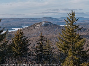
Next door to Coney Mountain, the Goodman mountain climb is slightly harder, and the views are not quite as good, but, it's a lot less crowded.
| Directions | From Long Lake, drive north on Route 30 towards Tupper Lake. After about 13 miles watch for the DEC post sign on the right. Don’t confuse Goodman Mountain with Coney Mountain. Coming from Long Lake you pass the Coney parking and Trailhead about one mile before you reach Goodman. |
| Difficulty | Easy. The round trip distance is three miles with 500 feet of elevation gain. |
| Family-Friendly | This is a great family hike with easy grades the entire way. |
| Winter | An easy and popular winter route. |
| One Thing to Know | The first half mile of the Goodman mountain trail is handicapped accessible with a (relatively) smooth surface. |
| NY DEC Webpage | Horseshoe Lake Wild Forest |
| Photo Gallery | Goodman Mountain Photo Gallery |
Goodman is a friendly little mountain with good views. The trail is partially along an old paved road and the climb gains just 500 feet over 1.6 miles. The mountain, and trail, were named to honor Andrew Goodman who spent summers in the area as a child. In 1963, Goodman and two others traveled to Mississippi to assist African Americans who wanted to register to vote. They were murdered by members of the Klu Klux Klan, a story that is recounted in the movie Mississippi Burning.

Goodman Mountain from Coney Mountain
Leaving the parking area the route crosses Cold Brook and ascends gradually. This is along an old roadway and pavement underlies this section of the trail, making it passable for wheelchairs and others with limited mobility. After 3/4 of a mile, the route turns sharply to the left and leaves the old roadbed. From there to the top the trail continues to climb steadily, but only a couple of short sections are even moderately steep. After rounding the end of the ridge the trail dips down slightly before climbing again to emerge onto the summit rocks.

Goodman Mountain trail map

Goodman Mountain Sign Board
